![]()
Site selection
The selection of a suitable measurement site for the SQ is crucial for the reliability and accuracy of the measurement results. Several aspects related to the hydraulic situation and the mounting of the sensor have to be considered.
Hydraulic requirements
Cross-Sectional velocity distribution
In general, the cross-Sectional velocity distribution at the measurement site must not be changed. For example, fluctuating inflows and regulated weirs can influence the measurements. Therefore a mini-mum distance to such influences of 5…10x the channel width up- and downstream of the measurement site is recommended. The following drawings illustrate some examples:

Figure 7 Positioning of SQ sensor under different flow conditions
Stationary waves
There must be no stationary waves present in the field of view of the SQ as they can negatively influence the measurement accuracy. Stationary waves may be caused by big stones and other obstacles; their impact depending on water level. Stationary waves cause errors in angle as the radar impulse is partly reflected from them and not the plane water surface. Also, they may overestimate the water level.
Range with unchanging cross Section
The cross-Section of the channel/river in the vicinity of the flow measurement needs to be stable. Pillars of bridges and bends or corners in the flow channel represent changes of the cross-Section. The minimum distance with a constant cross-Section upstream and downstream of the sensor should be 5…10x the channel width.
Stable cross-Section
The calculation of the discharge requires the cross-Sectional area of the channel/river (see Determination of water discharge). Therefore, the cross Section of the river must not change as this causes the need of a new site calibration. Examples of a changing cross-Section are erosion of the channel bed, deposition of debris or the relocation of sediments. Changes of the cross-Section may be identified by changes in the W-v relation.
Adequate wave movements
Waves or ripples with a height of at least 2 mm have to be present at the water surface over the full expected water level range. Especially very slow flowing rivers often do not meet this requirement (see also Flow velocity).
Influence of wind
For slow moving, deep rivers the flow velocity measurement may be interfered by waves which are caused by wind. If such an influence is observed, the measurement site should be shielded from wind by proper means or an alternative site should be considered.
Installation requirements
Viewing direction
It is recommended to install the SQ with its tip pointing upstream. This has some essential advantages: For installations on bridges the influence of pillars on the water flow conditions are avoided. Addition-ally, the influence of precipitation is eliminated by a direction separation obtained from the velocity spectrum (see Flow velocity).
Free field of view
The SQ sensor interprets all movements in its field of view. Therefore, no moving objects shall be present in the field of view of the SQ. Figure 8 shows the size of the measurement spot and its distance from the SQ sensor for different installation heights. Consider these dimensions when installing the sensor.

Figure 8 Measurement spot size for different mounting heights (dimensions in m)
Installation underneath bridges
When the SQ is installed underneath a bridge it has to be assured that no rain or melt water is dripping through the field of view of the velocity radar. The occurrence of such events may influence the measurement considerably.
Installation on extension arms
The SQ sensor can be mounted on an extension arm protruding from a river bank or channel wall. Sommer Messtechnik suggests installing a rotatable extension arm to facilitate maintenance.
Installation above open channels or rivers
The SQ can be mounted in a range between 0.25 to 6 m above the water surface. With the radar version this range can be extended to 0.05... 8 m above the water surface.
When the SQ is installed in an open channel or above a natural river it has to be assured that no rain or melt water from any structure above the sensor is dripping through the field of view of the velocity radar. The occurrence of such events may influence the measurement considerably.
Installation above half-pipes
The SQ can be used to determine the flow in small half-pipes as they are common in sewage networks. Due to the curved channel surface and the flow structure encountered, the minimum diameter of such a pipe is limited to about 150 mm.
When installing the SQ above a half-pipe follow the rules listed below:
- The SQ must not be mounted too close to any covered sections of the pipe. The closer it is mounted to covered sections, the more reflections may occur.
- The SQ must be mounted parallel to the water surface.
- The distance between the bottom of the pipe and the sensor should be the max. water level plus 250 ... 300 mm (see Figure 9).
- The space between the SQ and the water surface must be free of any obstacles. Any surface reflects the sensor signal and may cause interference.
- The level adjustment must be done at high water levels. In this way the SQ receives less reflections of the curved pipe surface.

Figure 9 Installation of the SQ above half-pipes
Installation in closed channels
In closed water channels such as discharge pipes multiple reflections of the sensor signal may occur. In a situation as illustrated in Figure 10 the radar signal is not only reflected at the water surface, but also on the channel wall. This may influence the measurement results. Multiple reflections are minimized by a smooth channel surface and channel designs without rectangular edges. For more in-formation on how to proceed if such an installation cannot be avoided please refer to .
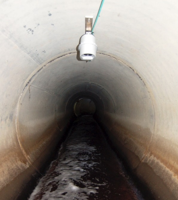
Figure 10 Installation of a SQ sensor in a water discharge channel
Documentation
It is recommended to document the measurement site with pictures for future analysis. These may include:
- Measurement site with the installed sensor
- River or channel facing upstream and downstream
- Flow conditions at the measurement site
- Roughness of the river bed or channel walls